Along the Tedori River...
Starting from the top of Mt. Hakusan, the Tedori River flows through a variety of different landscapes.
Tedori River Basin Overview
The basin that feeds into the Tedori River has a total area of 809km2. And with a length of 72km, the Tedori River is the longest river in Ishikawa Prefecture. Several tributaries flow down from the mountains, joining the river as it flows north, then upon reaching the Tsurugi district, turns sharply to the west at the head of the Tedori River Alluvial Fan, before making its way to the sea beside Mikawa. From the rugged, pristine mountains, to rice fields, and the estuary by the sea; in only a short distance the Tedori River follows a rich and varied landscape.
Tedori River Landscape:
The area around the Tedori River is over 90% mountains. In just a short distance the river travels from heavy snowfall mountains to the plains, flowing through various landscapes along the way.
Upstream Landscape
The area surrounding Mt. Hakusan, which forms the origin of the Tedori River, is easily erodible, and has frequent landslides. It supplies the majority of the sediment that flows into the river. Furthermore, the steep mountains create fast, powerful currents that carve deep V-shaped valleys into the landscape.
Midstream Landscape
On either side of the river, step-like terraces (river terraces) spread out. In the middle of this landscape, the river has carved a deep gorge with near vertical cliffs.
Alluvial Fan Landscape
Where the river leaves the mountains, much of the sand and stone carried from upstream is deposited, creating an alluvial fan. Here the ground is full of smooth, round stones that have been polished by the river over thousands of years.
Estuary Landscape
Here the river depth increases, and compared to further upstream, the flow is slow and calm. Here you can find beaches full of sand and small pebbles, the smallest of the sediments carried in the river.
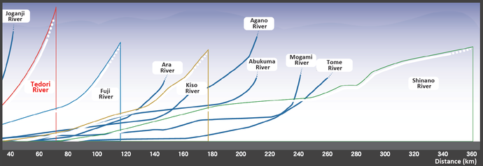
The Steepness of the Tedori River
As you can see in the graph, even amongst Japan`s steepest rivers (which are considered steep even internationally), the Tedori River is among the top. Flowing from 2,702m at the top of Mt. Hakusan, and over 72km to the sea, the river has an average gradient of 3.7% (1m drop per 27m).