Living with the Roaring Tedori River
The Tedori River is usually a gentle river bestowing numerous blessings. But the people of long ago have countless times experienced the wrath of this violent Tedori River.
Flood and Management History of the Tedori River
| 1881 | April flooding due to snowmelt and heavy rain (all levees breached; 46 villages affected; many rice fields destroyed). |
|---|---|
| 1885 | Tedori River falls under management of Ishikawa Prefecture. |
| 1891 | Consecutive flooding between July and August (5,523 levee breaches; 6 bridges destroyed, etc.). Rehabilitation work planned after inspection by Dutch engineer. |
| 1896 | 6 large floods decimate area (total 24 deaths; 40 injured; 58,974 levee breaches). |
| 1902 | Large flood occurs in July (10km of levee breaches; 1,443 towns inundated). |
| 1912 | Ishikawa Prefecture begins Sabo erosion-prevention work upon Mt. Hakusan. |
| 1927 | Upstream Sabo erosion-prevention work is taken over by the Federal Government. Ishikawa Prefecture begins erosion-prevention work further downstream. |
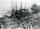
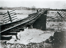
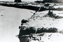
| 1934 | Massive flood occurs in July (97 deaths; 15 missing persons; 172 houses washed away; 65 houses collapsed; 586 houses inundated; 2,113 hectares of farmland damaged). |
| Tedori River Restoration Alliance formed (Current: Tedori River Basin Development Alliance). | |
| Federal Government forms “Tedori River Restoration Office” in Mikawa. Tedori River rehabilitation work planned (planned maximum flow rate capacity of 4,500m3/s). | |
| 1935 | Federal Government takes over Tedori River rehabilitation works. |
| 1942 | Ozo River erosion-prevention work taken over by Federal Government. |
| 1951 | Large scale excavation work begins using tower excavators (until 1963). |
| 1961 | Large flood in September after Typhoon #18 (57 houses flooded; 18 hectares of farmland flooded). |
| 1966 | Tedori River is designated as a nationally important river, and management is taken over by Federal Government. Plan formulated for various construction projects along the Tedori River and its tributaries (planned maximum flow rate capacity of 4,500m3/s). |
| 1968 | Dainichi River Dam construction is completed. Tedori River and tributary construction project is revised (planned maximum flow rate capacity of 5,000m3/s, river's standard maximum flow rate is estimated at 6,000m3/s). |
| 1974 | Tedori River Dam construction begins. |
| 1976 | Mikawa Tidal Gate construction completed. |
| 1980 | Tedori River Dam construction completed. |
| 1981 | Flood in July following rainy season (gabion washed away; river wall destruction). |
| Yasumaru River drainage station construction complete. | |
| 1998 | Flooding in September from Typhoon #7. Level of flooding comparable to that of 1934 but spared widespread devastation thanks to Tedori River Dam (Floodplain inundation; stone jetty destroyed). |
| 2004 | Debris flow occurs in Betto Valley (suspension bridge destroyed; 23 check dams damaged). |
Damage from the Great Tedori River Flood of 1934