Mt. Hakusan Hike


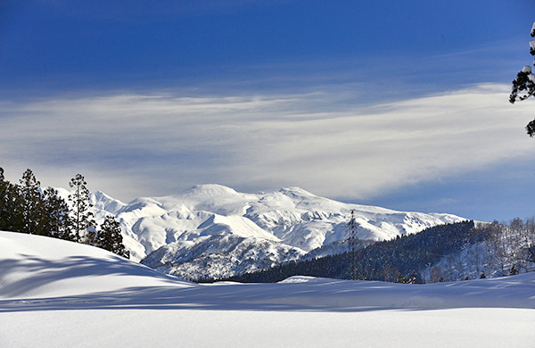
Mt. Hakusan is one of the three most sacred mountains in Japan, along with Mt. Fuji and Mt. Tateyama. The mountain towers high above the surrounding peaks and is covered in bright white snow throughout the winter and into early summer, hence its name, which means “white mountain.”
Mt. Hakusan has a long history that dates back over 100 million years, to a time when the area was inhabited by dinosaurs and covered in lakes and waterways. The mountains visible today were formed by volcanic eruptions around 400,000 years ago.
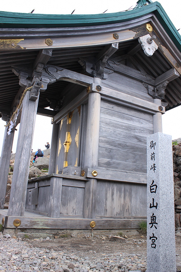
According to legend, the first person to successfully climb the peak was the Buddhist priest Taicho (682–767), who made the ascent in 717. Taicho is an important figure in Shugendo, an ascetic religion that combines precepts of Buddhism, Shinto and mountain worship. The religious connection to the mountain is still alive today: Hakusan Shirayama-Hime Okumiya Shrine sits at the top of Gozengamine (2,702 m), the highest of Hakusan’s three peaks.
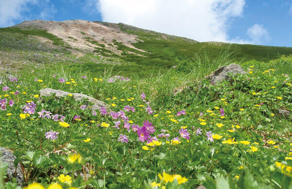
Mt. Hakusan is the jewel of Hakusan National Park, which extends into Ishikawa, Fukui, Gifu, and Toyama prefectures. A wide range of ecosystems thrive here. Visitors who climb the mountain will pass through forests of Japanese beech (buna) and Erman’s birch (dakekanba). Higher up, the trees thin out and give way to alpine meadows that are dotted with colorful flowers throughout the summer. Many mammals, birds, and amphibians call the park home; these include golden eagles, foxes, and Asiatic black bears. Mt. Hakusan was designated a UNESCO Biosphere Reserve in 1980.
Hakusan
The peak where sacred and natural meet
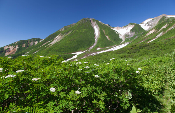
The heart of Hakusan National Park is Mt. Hakusan, which rises to a towering 2,702 meters; the park extends into Ishikawa, Fukui, Gifu and Toyama prefectures. This mountain is also one of Japan’s most sacred, along with Mt. Fuji and Mt. Tateyama. Its name means “white mountain,” and during the winter it is covered with a thick layer of snow. In the spring, green shoots push through the snow, eventually leading to the fields of colorful alpine flowers that bloom throughout the summer. During the autumn, the forests are tinged with flaming red, orange, and yellow leaves.
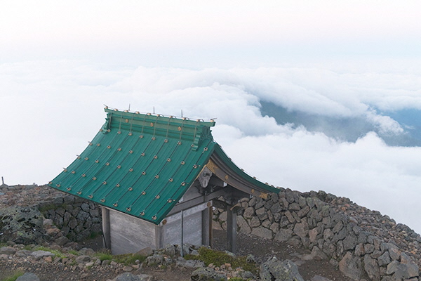
The mountain has been considered sacred ever since Buddhist priest Taicho (682–767) climbed it in 717. Taicho was a practitioner of Shugendo, a religion that combines Buddhism, Shinto and mountain worship. Practitioners often train and perform ascetic rites on sacred mountains. This connection to the sacred is evidenced by Hakusan Shirayama-Hime Okumiya Shrine, which is located at the top of Gozengamine (2,702 m), the highest of Hakusan’s three peaks. The Hakusan Okumiya prayer hall is located in front of the Murodo mountain hut.
When conditions are right, visitors may get to witness a “sea of clouds” (unkai), an impressive layer of unbroken clouds seen from above, with the peaks of the Northern Japanese Alps towering in the distance.
Hakusan is a volcano, with its last known eruption occurring in 1659. Although quiet today, it still heats the many hot springs (onsen) around its base.
A wide range of ecosystems thrive on Hakusan. Visitors who climb the mountain will pass through forests of Japanese beech (buna) and Erman’s birch (dakekanba). Higher up, the trees thin out and give way to alpine meadows dotted with colorful flowers throughout the summer, some named after the mountain, such as Hakusan kozakura (Primula cuneifolia Ledeb. var. hakusanensis) and Hakusan furo (Geranium yesoemse var. nipponicum). Many mammals, birds and amphibians inhabit the park, including golden eagles, foxes, and Asiatic black bears. Hakusan was designated a UNESCO Biosphere Reserve site in 1980.
Introduction to Hakusan
Welcome to Mt. Hakusan, one of Japan’s most sacred mountains. For centuries, these peaks have fascinated nature lovers and enlightenment seekers alike as one of the oldest natural sacred sites in the country.
History
Hakusan’s history is shrouded in legend. The Buddhist priest Taicho (682–767) is credited with first summitting the towering peak in 717, establishing it as a sacred mountain. By the ninth century, three pilgrimage trails had been created for worshippers, and temples and inns catering to their needs were built along the trails.
Buddhism and Shinto coexisted peacefully for centuries, as exemplified by Taicho himself, who was a major figure in Shugendo, a religion combining mountain worship with Buddhism and Shinto. Believers from all walks of life made their way to the sacred mountain to worship.
This changed with the advent of the Meiji era (1868-1912), a time of rapid modernization in Japan. One of the most dramatic actions taken by the government was shinbutsu bunri, the strict separation of Shinto and Buddhism. This practice led zealots to suppress the latter.
Local people in the villages around Hakusan, however, wanted to preserve their local deities. Instead of allowing the Buddhist statues which had dotted the mountain for centuries to be destroyed, they quietly removed them and hid them in the villages below. Known as gezan butsu (“Buddhas who descended the mountain”), these statues are safely enshrined in two spots in the foothills of Hakusan.
As mountain climbing grew in popularity throughout the twentieth century, the trails and mountain huts in the area were improved. Hakusan National Park was established in 1962 to protect the natural environment, and in 1980 it was designated a UNESCO Biosphere Reserve.
Reaching the Peak
The original ninth-century trails are still in use. The trails allowed Buddhist worshippers and climbers to access the peak from three different directions. The Kaga-Zenjodo Trail starts in Ishikawa Prefecture, while the east-bound Echizen-Zenjodo Trail begins in Fukui Prefecture. The Mino-Zenjodo Trail approaches leads north from Gifu Prefecture to the mountain.
Hakusan Shrine
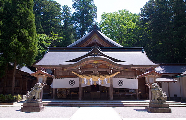
Trekkers will find a Hakusan Shrine at the start of each of the trails, where climbers often stop to pay their respects before starting their ascent. Shirayama-Hime Shrine, or “white mountain princess shrine,” is the starting point of the Kaga-Zenjodo. It is also the head shrine for some 2,700 Hakusan shrines across Japan. Heisenji Hakusan Shrine marks the entrance to the Echizen-Zenjodo trail, while Nagataki Hakusan Shrine welcomes hikers to the Mino-Zenjodo route.
The sacred and the snow
Religious traditions associated with Hakusan, known as Hakusan shinko, are alive and well, with many ceremonies held throughout the year at the shrines around the base of the mountain.
Shirayama-Hime Shrine is a popular destination for hatsumode, the first shrine visit of the New Year. Traditionally this is an occasion to give thanks for good health during the previous year and pray for a good harvest in the New Year.
Hakusan gets more snow than other areas around the world at the same latitude. The village of Shiramine, at the base of the mountain, receives some 6 meters of snow per year, with up to 10 meters falling at higher elevations. The snow is an obstacle to mountain climbing, agriculture, and forestry, but it is also a blessing, as it is an important water source for a vast area of Japan.
The climbing season runs from May to October, with the peak season falling around July and August. Around 50,000 people climb Hakusan every year, many of whom get up extra early to witness the sunrise from the highest peak, Gozengamine.
The blessings of Hakusan
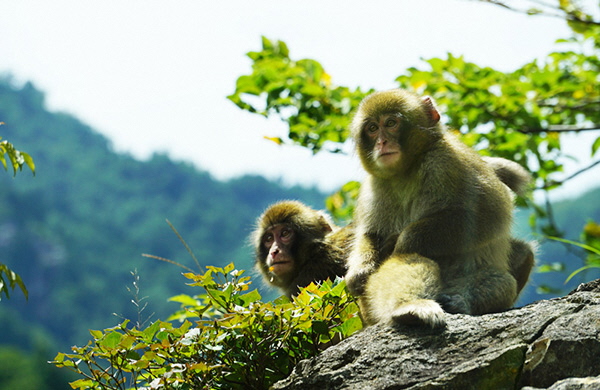
Hakusan’s climate and topography allow many ecosystems to thrive, resulting in great biodiversity. The forests that extend up from the base of the mountain are the habitat of mammals such as macaques, serow, the Asiatic black bear and several different weasel species. The skies and treetops are filled with avian life from songbirds to raptors, including the rare golden eagle.
Wild vegetables (sansai), such as fern, bamboo and other early-spring shoots, grow prolifically here and are used in a variety of local dishes.
Four main rivers, along with many small streams, flow down from the mountains: the Tedorigawa River, Shogawa River, Nagaragawa River and Kuzuryugawa River. Several fish species make their home in these waterways, most notably iwana (Salvelinus leucomaenis, a landlocked char) and yamame (cherry salmon; Oncorhynchus masou).
The rivers supply meltwater to the rice fields on the flatlands below Hakusan, and also provide hydroelectric power for several nearby prefectures. As Hakusan is an active volcano, it heats the water in a number of hot springs (onsen), where local residents and visitors alike enjoy soaking in the relaxing baths.
Park Facilities
Hakusan National Park covers an area of 49,900 hectares, all of which is designated a Nature Conservation Area. About 36 percent of the park is considered a Special Zone of environmental protection.
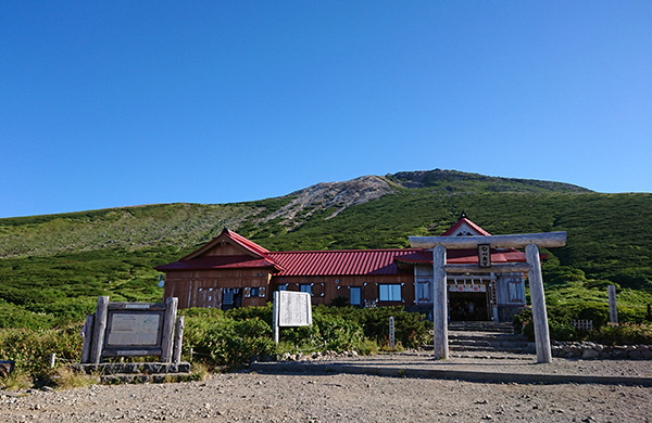
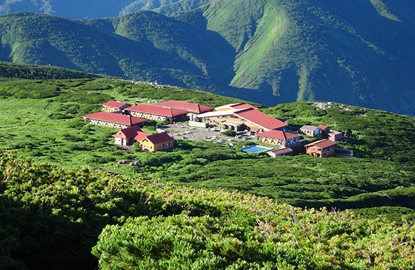
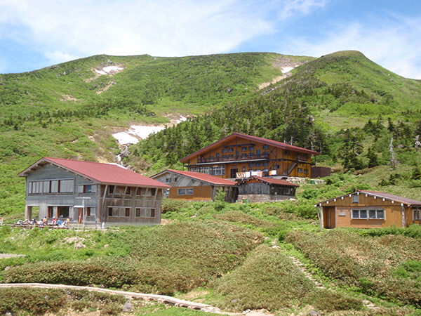
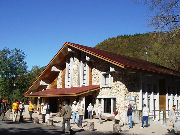
The largest facility for hikers and climbers is the Murodo Visitor Center and Lodge, located at the foot of the lofty Gozengamine peak. The lodge is housed near the grounds of Shirayama-Hime Shrine, and has been welcoming climbers for hundreds of years. Today, Murodo is operated by the Hakusan Tourism Association, and provides visitors with a place to stay and eat within the national park.
Natural Protection
Local villagers once hunted bears for their meat and fur, and for use in traditional Japanese medicine. Since 1969, however, the Wildlife Protection and Hunting Law has banned the hunting and capture of animals throughout most of the park.
The National Hakusan Wildlife Sanctuary is a safe haven for a variety of species, and has played an important role in the revival of the serow (kamoshika; Capricornis crispus). In the postwar years, the number of serows dropped dramatically, leading to this indigenous goat-like creature being designated a strictly protected Special Natural Monument in 1955. Today, the population of serows continues to increase, and visitors may well spot one of these unusual animals while exploring the park’s trails.
Hakusan Tedorigawa National Geopark was established in 2011, and encompasses the summit of Mt. Hakusan, the Tedorigawa River basin, and Tedori Gorge. Dinosaur fossils have been discovered in one section of the park, making it an important area for paleontological research.
Notes on Climbing Mt. Hakusan
- Watch the weather. Conditions can change quickly in the mountains, particularly on a high peak like Hakusan. Even if the weather looks good, be sure to check the forecast, and be prepared to cancel or change plans, especially during typhoon season. Hike or climb at your own risk, and do not climb at night.
- Hakusan is an active volcano. Be sure to check conditions and warnings before beginning your climb.
- Arrive early. Hiking in the dark is dangerous, so start from the trailhead early. If you’re staying on the mountain, arrive at the hut or camping ground at least a few hours before sunset.
- Be ready for emergencies. Always carry rainwear, warm clothing, a change of clothes, plenty of water, and emergency food.
- Share your plans. Everyone climbing Hakusan is required to fill out climb report forms before starting the ascent. These forms are available at all trailheads. Be sure to inform friends or family of your route and schedule as well.
- Look, but don’t touch. The National Parks Act forbids the collection of animals, plants, or rocks from the mountain. Bringing foreign plants or animals into the park is also forbidden. Anyone caught doing so will be fined.
- Stay on marked trails. For your own safety and to protect the delicate alpine plant life and the mountain itself, avoid going off-trail.
- Warn the bears. If hiking alone, use bear bells, a radio, or other means of making noise to alert bears to your presence and avoid startling them. Attacks are rare, but all hikers should take precautions.
- Hike off-peak. From late July through August, the trails and huts will be crowded on weekends or holidays. Visit on weekdays to avoid the crowds.
- Watch for winter-like conditions in spring and autumn. Even on warm days, conditions on the mountain can quickly turn cold and snowy. Always check weather forecasts and carry clothing and gear appropriate for snowy conditions.
- Carry out your garbage. There are no garbage disposal facilities on the mountain, so climbers are required to carry out everything they bring in.
- Bicycles or other wheeled vehicles are not allowed on Hakusan.
- Camping in tents is only allowed at Minami Ryugabanba.
In case of emergencies, dial 110 for the police. English-speaking officers are not common, so speak slowly and use a few key words, such as “Hakusan,” “climbing,” and “accident.” The police will contact a translator and return your call. If you are using a mobile phone, they will usually be able to pinpoint your location.
Hakusan Murodo Lodge
Hakusan Murodo is a major base for hikers in Hakusan National Park, located at the foot of Gozengamine at 2,450 meters. The facilities were renovated in 2002, and are equipped with drying rooms for wet clothes and outside toilet facilities. There are two separate facilities here: Hakusan Murodo includes four large lodges, while Hakusan Raicho-so is a separate building with six private rooms.
“Murodo” originally designated places where believers could both lodge and worship. Appropriately, the lodge is right in front of Hakusan Okumiya Shrine. The shrine holds ceremonies and sells small omamori, amulets to protect hikers on their journey. In good weather, a priest will leave the shrine early in the morning to hold a sunrise rite at the peak.
Raicho-so’s name refers to the rock ptarmigan (raicho), a member of the grouse family found only in Japan. The name means “thunder bird,” and according to legend, the birds’ presence protects against lightning and fire.
Hakusan Raicho-so
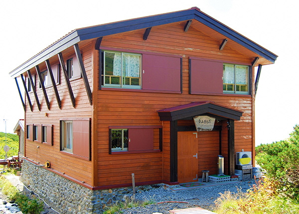
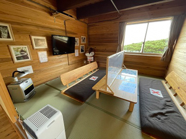
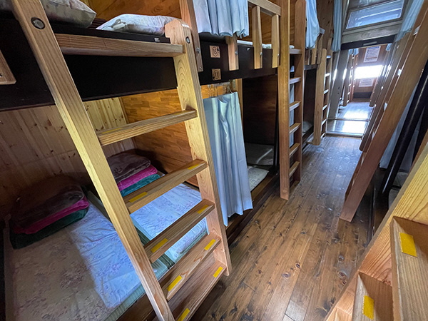
Located close to the Hakusan Murodo lodges, Raicho-so provides six private rooms for visitors and is open from July 1 until early October. Note that there are no cooking facilities in the lodge, and stoves and other sources of fire are prohibited.
Lights are turned off at 8:30 p.m. until August 31, and at 8:00 p.m. from September 1 onward.
There are six rooms on the second floor: three rooms accommodating three guests each, and three larger rooms for groups of four. Each room has a television and a heater.
Guests may use the shared facilities on the first floor; there are pay toilets, two coin-operated showers, a laundry room and drying room. There is also a lounge with a television, massage chairs and Internet connection.
* The pay toilets and coin-operated showers may not be available; in this case, the relevant fees will be deducted from the total cost.
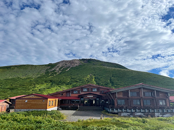
Nanryu Sanso Lodge
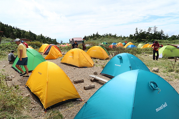
Nanryu Sanso is located at an altitude of 2,080 meters in Minami Ryugabanba, a gentle bowl just to the south of the main peaks of Mt. Hakusan. Many hikers overnight here before ascending Gozengamine (2,702 m), the highest of Hakusan’s peaks, or heading up Mt. Bessan (2,399 m) to the south. Near the main lodge, visitors will find the Minami Ryugabanba Visitor Center, the Nanryu ga Banba Campsite (the only designated tent-camping site in all of Hakusan), and private cabins that must be booked in advance.
Late July and early August is peak season for Nanryu Sanso, especially on weekends. Plan and reserve accommodation well in advance, and avoid weekends if possible.
Please take all trash home with you, as there is no place to dispose of it on the mountain.
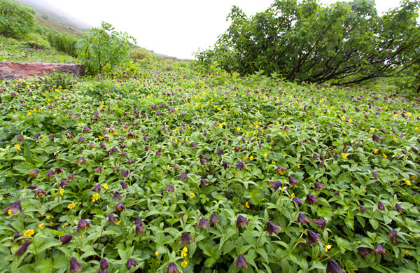
Alpine flower blooming seasons
Over 250 varieties of alpine and subalpine wildflowers bloom on Mt. Hakusan. Approximate flowering dates for typical flowers are from early July to late September.
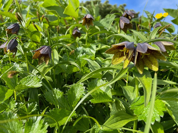
A dark-brown lily usually found in grassy areas
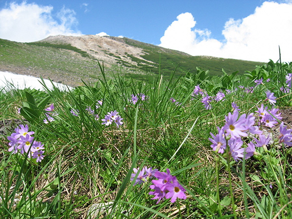
An herbaceous plant with pink flowers, found in moist areas and around snow patches
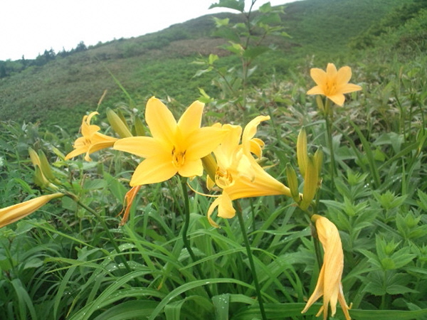
A yellow lily found in grassy areas
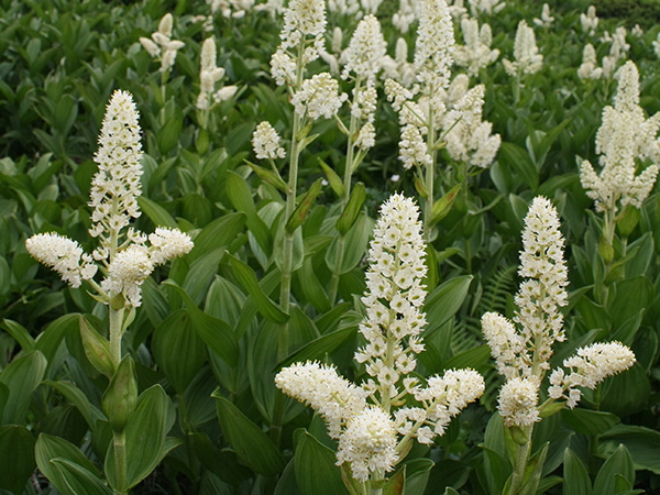
Poisonous, feathery white flowers found in moist areas
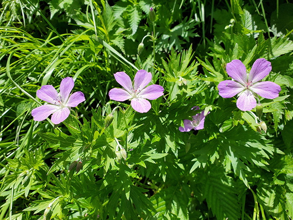
A five-petaled pink flower found in grassy areas
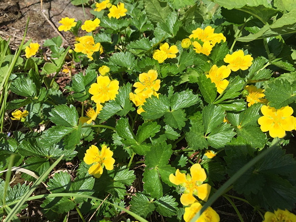
A plant from the rose family with small yellow flowers, often found in gravelly or moist areas
Sunrise ceremony on the peak
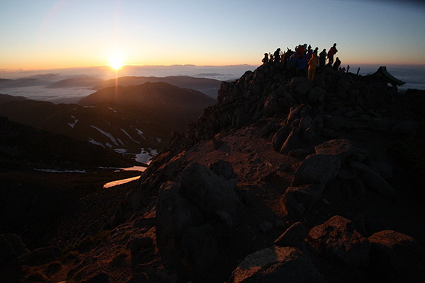
As Mt. Hakusan is one of the most sacred peaks in Japan, it is no surprise that the mountain is the site of sacred rites. One particularly dramatic ritual leads many climbers to wake before dawn to catch the sunrise at the top of Gozengamine (2,702 m).
On days when the weather is cooperative, a drum will sound from the shrine at Murodo one hour before sunrise. A Shinto priest will then hike up to the summit, navigating the steep path in high wooden geta clogs. At the peak, he will climb up onto the rocks and lead those who have gathered in shouting banzai! as they face toward the sunrise, to welcome the birth of a new day and pray for world peace and safety on the trails. This is a memorable way to start the day and experience the power of this sacred peak.
Get to Know Hakusan National Park
Ichinose Visitor Center
The center provides a wide range of information on the animals, plants, and rich history and geology of Hakusan Natural Park. Exhibitions, videos, and maps ensure visitors are fully informed before setting out on the trails. Staff will happily explain the various routes, and can provide the registration forms that everyone climbing Mt. Hakusan is required to fill out.
Nature Trails
For those who prefer to remain at lower altitudes, the Visitor Center is close to several nature trails. Guided nature walks are also held regularly; please ask the staff for more information.
Access
By car
From Toyama, Niigata, Nagano or Tokyo to Shiramine/Betto-deai
- Hokuriku Expressway: Exit at Hakusan IC
- Go to Hakusan area on Route 157
- Go to Katsuyama/Shiramine
- Turn left at the Shiramine intersection and continue on prefectural road # 33 of Hakusan Koen Line (1 hr.)
- Go to Betto-deai parking lot through Ichinose (40min)
Parking: 200 vehicles (Free)
From Nagoya or Gifu to Shiramine/Betto-deai
- Tokaido Expressway: Exit at Shiratori IC (Abura-zaka)
- Go to Ono/Katsuyama area on Route 158
- Turn right at the Nagayama-machi intersection and enter Route 157 (2 hrs. and 30min)
- Continue in the Kanazawa/Shiramine direction, turn right at the Shiramine intersection (30min), and enter Prefectural road # 33 of Hakusan Koen line
- Go to Betto-deai parking lot through Ichinose (40min)
Parking: 200 vehicles (Free)
From Fukui, Shiga or Osaka to Shiramine/Betto-deai
- Meishin Expressway
- Hokuriku Expressway: Exit at Fukui-North IC
- Go to Katsuyama on Route 416
- Turn left at the Kouri-machi intersection and enter Route 157 (40min)
- Continue to Kanazawa/Shiramine, turn left at the Shiramine intersection, and enter Prefectural road #33, Hakusan Koen Line (30min)
- Go to Betto-deai parking lot through Ishinose (40min)
Parking: 200 vehicles (Free)
From Shiramine to Betto-deai
- Take Prefectural road #33 (30min) to Betto-deai via Ichinose. (40 min)
Parking: 200 vehicles (Free)
[Notes]
- In the "my-car" control season (July ~ Oct.), park in the Ichinose parking lot (700 vehicles, free) and take the shuttle bus (charged) to Betto-deai, where the trailhead is.
- Prefectural road #33 Hakusan Koen Line may be closed due to weather conditions. Please pay close attention to the forecast, and do not climb the mountain if it is likely to rain heavily. In addition, in the off-season, the road may be closed. Please check the situation beforehand.
- Inquiries: Ishikawa Prefectural General Office of Public Works: TEL 076-272-1188
By JR
From Tokyo
- Hokuriku Shinkansen
- Kanazawa Station
- Matto Station
The next morning, take the "Hakusan Tozan Bus" to Betto-deai.
From Nagoya/Maibara
- JR Limited Express "Shirasagi"
- Tsuruga Station
Transfer to Hokuriku Shinkansen - Komatsu Station
Transfer to IR Ishikawa Rail way - Matto Station
The next morning, take the "Hakusan Tozan Bus" to Betto-deai.
From Osaka
- JR Limited Express "Thunderbird"
- Tsuruga Station
Transfer to Hokuriku Shinkansen - Komatsu Station
Transfer to IR Ishikawa Rail way - Matto Station
The next morning, take the "Hakusan Tozan Bus" to Betto-deai.
Hakusan Tozan Bus (about 2 hrs.)
This year during the climbing season, there will be a bus service operating from IR Matto Station to Ichinose Visitor Center.
Once you arrive at Ichinose, please change to the shuttle bus to get to Betto-deai, which is the beginning of the climbing course.
Next year this bus service will also operate from Kanazawa Station.
Inquiries:Map Co.,Ltd Telephone Service Center:Tel 076-249-7300
By Plane (Komatsu Airport)
By taxi
- In the climbing season, Komatsu Taxi's "Hakusan Tozan Express" (reservation required) is convenient.
Inquiries: Komatsu Taxi (reservation required) toll-free number: 0120-87-0887
By rental car (about 2 hrs.)
- Drive from Komatsu Airport to Yoshinodani via Torigoe on Route 360, and turn right at the Yoshinodani intersection in the direction of Katsuyama/Shiramine and enter Route 157.
[Note]
In the "my-car" control season (July ~ Oct.), park in the Ichinose parking lot (700 vehicles, free), take the shuttle bus (charged) and get off at Betto-deai, where the trailhead is.
Or take the bus to Kanazawa Station from the airport.
The next morning, take the Hakusan Tozan Bus from Kanazawa Station Kenrokuen exit (Platform #1) and get off at Betto-deai (last stop).
Accommodation Reservations and Inquiries
Reservations are accepted by telephone or at the reception counter starting at 9:00am on April 1 every year. (Please be aware that the reservation counter is not only for reservations.)
Reservation Center for Hakusan Murodo/Raicho-so: Tel 076-273-1001
* If you call at the beginning of April, you may not get through to the receptionist right away, because the line will be busy.
For further information, please see the following website: "Hakusan Best Guide".